
Introduction
The Divisional Forest Office (DFO), Wangdue, was established in 1990 to oversee the sustainable management, conservation, protection and service delivery of forest resources within its jurisdiction. The divisional headquarters is located at Lobesa in Barp Gewog, under Punakha Dzongkhag, providing administrative oversight for forest management activities across both Punakha and Wangdue Phodrang Dzongkhags.
Situated in the west-central region of the country, Divisional Forest Office (DFO), Wangdue, looks after 25 gewogs (10 gewogs in Punakha Dzongkhag and 15 gewogs in Wangdue Phodrang Dzongkhag) with an approximately forest cover of about 259,187.7 hectares (2,591.87 km²), representing as forest division the country.
The Division is responsible for managing a remarkably diverse landscape, with elevations ranging from 371 to 4,657 meters above sea level. This wide altitudinal gradient supports a wide variety of ecosystems, climatic zones, and vegetation types, ranging from subtropical broadleaf forests in the low-lying valleys to alpine meadows in the higher elevations.
Consequently, the Division is endowed with rich biodiversity and provides critical ecosystem services, including watershed protection, wildlife habitat conservation, carbon sequestration, and sustainable forest resources that support the livelihoods of local communities.
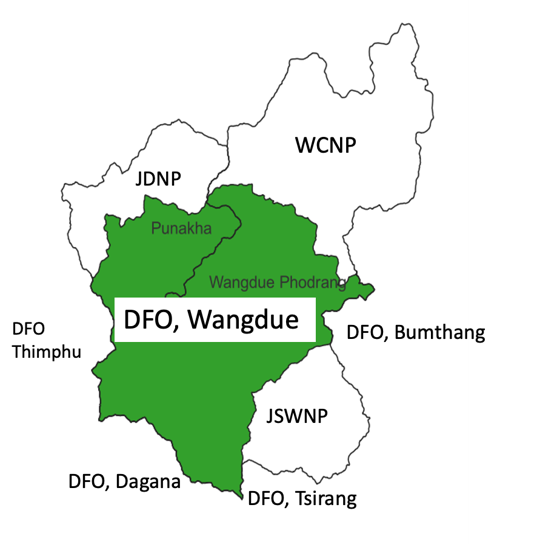 |
Figure 1: Administrative map of DFO, Wangdue
Vision
“Protection, conservation, and sustainable management of Bhutan’s natural resources to deliver socio-economic benefits for citizens, driven by professional excellence, robust information systems, and advanced forestry science”
Mission
“To fulfill the people’s aspirations through different sustainable forest management regimes and conserving a healthy forest ecosystem”
Core Mandates
- Manage and utilize Wangdue Phodrang and Punakha’s forests for sustainable production of economic and environmental goods and services to meet the needs of the people.
- Enhance long term sustainability of Wangdue Phodrang and Punakha’s biodiversity and ecosystem services through management of natural habitats.
- Sustainable forest management through effective application of science and technology including participation of communities for socio-economic benefits.
- Forest landscape restoration for social, ecological and economic benefits.
- Generate forestry data to develop scientific knowledge to enhance forest and biodiversity management to support implementation and ecologically sound policies.
- Periodic monitoring of forest resources and evaluation to ensure sustainable management and information dissemination.
- Delivering effective and efficient forestry services to the people unstintingly as per the forest Act and Rules.
- Ensuring that the implementation and enforcement of forestry rules, regulations and programs are in line with the plans and policies of the department.
Office Information:
Office Email address: wangduefd@moenr.gov.bt
Office Phone Number: 03-741205/03-741221
Postal Address: Post Box No. 1265, Divisional Forest Office, Wangdue
Official Facebook page: Divisional Forest Office, Wangdue
Departmental Website: https://www.dofps.gov.bt/wangdue-division/

Figure 3: Organogram of the Division
Individual Official Contact Information:
- Chief Forestry Officer – Mr. Tashi Wangchuk – email: tashiwangchuk@moenr.gov.bt. Phone: 17113920.
- Forest Monitoring and Information Section – Mr. Tsheringla (Section Head) – email: tsheringla@moenr.gov.bt. Phone: 17978388.
- Forest Resources Planning and Management Section- Mr. Kaka (PFO), Section Head. Email: kaka@moenr.gov.bt. Phone: 17650670.
- Nature Conservation Section – Ms. Kezang Wangmo (Dy. CFO), Section Head – email: kezangwangmo@moenr.gov.bt. Phone: 17823532.
- Administration and HR Section – Mrs. Jamyang Lhamo – email: jamyanglhamo1988@gmail.com. Phone: 17889845.
- Punakha Range Office – Mr. Wangchuk- email: wangchuk@moenr.gov.bt. Phone: 17621844.
- Wangdue Range Office – Mr. Wangda – email: kelwangs1984@gmail.com. Phone: 17623664.
- Nobding Range Office – Mr. Tshewang Namgyel – email: nobdingrangeoffice@gmail.com. Phone: 17560810.
- Lobesa Range Office – Mr. Ngawang Gyeltshen – email: ngawanggyeltshen@moenr.gov.bt. Phone: 17620368.
- Gogona Forest Management Unit- Mr. Damber Mani Rai – email: manid1374@gmail.com. Phone: 17654324.
- Khotokha Forest Management Unit – Mr. Nar Bdr. Pradhan – email: narbdrpradhan@gmail.com. Phone: 17610535.
- Royal Botanical Park, Lampelri – Mr. Sangay Dorji (PFO) (In Charge), email: sndorji@gmail.com. Phone: 77730246
Sections under the Division and mandates
- Administration and HR Section
- Handles staff leave records and ensures that all staff ‘s official matters are complied with the Civil Service Reform Act.
- Handles the internal placement and transfers of staff in consultation with the Head of Division.
- Facilitates the tendering and procurement of office equipment, stationery, and essential field materials. Manages asset tracking and disposal in alignment with RGOB Financial Manuals.
- Manages the division’s pool of vehicles, including fuel allocations, maintenance schedules, and trip/tour authorizations for field visits.
- Maintains files, drafts and dispatches official correspondence, arranges division meetings, and provides a conducive working environment for technical and support staff.
- Assists in the preparation of the division’s annual work plans regarding utilization and tracking of administrative budgets, and ensures financial transactions undergo proper Revenue Administration Manual.
Human Resources of the Division
| Office Wise | Technical | Non-Technical Staff |
| Division HQ | 11 | 3 |
| Royal Botanical Park, Lampelri | 3 | 0 |
| Lobesa Range Office | 9 | 1 |
| Punakha Range Office | 22 | 1 |
| Wangdue Range Office | 23 | 1 |
| Nobding Range Office | 8 | 1 |
| Gogona FMU | 4 | 1 |
| Khotokha FMU | 5 | 1 |
| Sub-Total | 85 | 9 |
| TOTAL (Technical & Non-technical staff) | 94 | |
- Nature Conservation Section (NCS)
- Wildlife Conservation and Management – Plan, coordinate, implement, and monitor wildlife conservation programs, habitat improvement, and biodiversity research and surveys.
- Protected Area and Conservation Planning – Identify, plan, monitor, and provide technical support for the preparation and review of conservation management plans for protected and other conservation areas.
- Human-Wildlife Conflict Management – Coordinate human-wildlife conflict mitigation programs, capacity-building initiatives, rescue and rehabilitation activities, and monitor conflict-related insurance schemes.
- Awareness and Capacity Building – Conduct environmental education, conservation awareness, and training programs on wildlife conservation, human-wildlife conflict, snakebite management, and relevant forestry legislation.
- Technical Support and Information Management – Provide technical guidance to field offices, maintain biodiversity databases, and manage records of wildlife trophies and seized wildlife specimens.
- Ecotourism and Conservation Promotion – Develop educational materials, publish pictorial guidebooks on flora and fauna, and promote sustainable ecotourism products and facilities.
Flagship Species
1. Mammals
- Royal Bengal Tiger (Panthera tigris)
- Red Panda (Ailurus fulgens)
- Golden Langur (Trachypithecus geei)
- Dhole (Cuon alpinus)
2. Birds
- White-bellied Heron (Ardea insignis)
- Pallas’s Fish Eagle (Haliaeetus leucoryphus)
- Black Necked Crane (Grus nigricollis)
3. Fishes
- Golden Mahseer (Tor putitora)
4. Butterfly
- Bhutan Glory (Bhutanitis lidderdalii)
- Blue Admiral (Kaniska canace)
5. Amphibian
- Tree Frog (Polypedates himalayensis)
- Montane Cascade Frog (Amolops monticola)
- Himalayan Newt (Tylototriton verrucosus)
- Liebig’s hill frog (Nanorana liebigii)
Biodiversity information of the Division:
- Total Mammal recorded – 38 species
- Total Birds recorded – 293 species
- Total Butterflies recorded – 166 species
- Total trees & shrubs recorded – 106 species
- Total herbs recorded – 143 species
- Total Orchids recorded – 222 species
- Total fishes – recorded 15 species
- Total Amphibians recorded – 9 species
- Forest Resources Planning and Management Section (FRPMS)
The Forest Resources Planning and Management Section (FRPMS) serves as the technical and planning arm responsible for sustainable management, conservation, and utilization of forest resources. The section ensures that forest management interventions are scientifically sound, environmentally sustainable, and aligned with national forestry policies, legislation, and strategic development priorities.
The following are the mandates of the section:
- Coordinate community-based forest resource management through planning and implementation of activities in Community Forest and Non-wood Forest Product management area.
- Provide technical support for preparation/revision of Community Forests and NWFP Management Plans.
- Facilitate and support the establishment of Private Forests.
- Coordinate plantation and agroforestry programs.
- Facilitation of Community Forest Networking Group and provide technical support.
- Prepare, revise, and implement Forest Management Plans (FMPs) for Forest Management Units (FMUs), Local Forest Management Areas (LFMAs), Community Forests (CFs) Non-Wood Forest Product Groups (NWFP), and other managed forests.
- Prepare annual operational and work plans for the forest management units.
- Implement scientific thinning works to promote the sustainable production of timber and other forest products while generating revenue.
- Facilitate timber supply for construction and renovation of Lhakhangs and other religious structures.
Approved Community Forest
| Sl. No. | Dzongkhag | Total CFs (Nos) | Total Area (Acre) | No. of HH |
| 1 | Punakha | 41 | 11,601.15 | 1,381 |
| 2 | Wangdue Phodrang | 88 | 17,270.079 | 2,480 |
| TOTAL | 129 | 2,8871.229 | 3,861 |
Approved Non-Wood Forest Management and Marketing Groups
| Sl. No. | Dzongkhag | Total no. of NWFP groups | Total area (ha) | No. of HH |
| 1 | Wangdue Phodrang | 4 | 16135.59 | 795 |
| TOTAL | 4 | 16135.59 | 795 |
Approved Local Forest Management Areas (LFMA)
| Sl. No. | Dzongkhag | Total LFMA | Total AAC (m3) | Total Area (Acre) | Area (Ha) | Gewog |
| 1 | Punakha | 3 | 5363 | 18,710.24 | 20,410.00 | Kabjisa, Barp and Toebisa |
| 2 | Wangdue Phodrang | 9 | 46120 | 157,993.363 | 289,960.19 | Daga, Phobjikha, Gangtey, Sephu, Nahi, Bjena, Gasatsho Wom, Kazhi |
| TOTAL | 12 | 51,755 | 176,703.603 | 316,343.37 |
- Forest Monitoring and Information Section (FMIS)
- Provide services through Online Forestry Services (OFS) platform.
- Provide services through the Government to Citizen Services (G2C) platform.
- Compilation and submission of annual monitoring reports of FMU, CFs, NWFPs, LFMA and BC2
- Forest fire monitoring and facilitation during forest fires including post fire assessments
- Monitoring of Rural House Building Timber utilization
- Compliance monitoring of Forestry Clearances issued
- Provide legal advice in compounding and settlement of forest offense cases and follow-up on forest protection and legal issues
Forest-Based Industries (FBIs)
| Forest-Based Industries | Dzongkhag | |
| Wangdue Phodrang | Punakha | |
| A. Wood-Based Industries | ||
| Logging Unit | 8 | 0 |
| Integrated WBI | 1 | 0 |
| Stationary Sawmill | 11 | 2 |
| Mobile Sawmill | 7 | 1 |
| Furniture Unit | 15 | 10 |
| Wood production and manufacturing unit | 4 | 0 |
| Drum Manufacturing Unit | 0 | 2 |
| B. Non-Wood Based Industry | ||
| Incense Manufacturing Unit | 3 | 1 |
| Sub-Total | 49 | 31 |
| Total | 80 | |
Field Offices under the DFO, Wangdue
- Punakha Range Office
- Wangdue Range Office
- Nobding Range Office
- Lobesa Range Office
- Khotokha Forest Management Unit
- Gogona Forest Management Unit
- Lampelri Royal Botanical Park
1. Punakha Range Office
The Punakha Range Office is located at Dapchegang, near the Guma gewog Administration Office in Punakha Dzongkhag. It has administrative jurisdiction over the gewogs of Guma, Talo, Shengana, Kabjisa, Dzomi, Chubu, Toewang, and Lingmukha. The office occupies approximately 1.50 acres of land at an elevation of about 1,275 meters above mean sea level.
Established in 1987 at Mochhu Park near Punakha Dzong, the Range Office was relocated to its present site at Dapchegang in 2011, approximately two kilometers from the Dzong. It currently provides forestry-related public services to around 3,100 households, supporting sustainable forest management, biodiversity conservation, and the delivery of forestry services to local communities across its jurisdiction.
The Punakha Range Office manages five Beat Offices, namely:
- Kabjisa Beat Office
- Samdingkha Beat Office
- Shengana Beat Office
- Talo Beat Office
- Tshochasa Beat Office
In addition to coordinating and supervising the Beat Offices under its jurisdiction, the Punakha Range Office directly manages forestry activities and delivers public services in Guma and Dzomi Gewogs. The Beat Offices serve as field-level units responsible for implementing forestry programs, including forest protection and patrolling, regulation of timber and non-wood forest product utilization, processing of forestry permits, support to community forestry, biodiversity conservation, and promoting sustainable natural resource management through public awareness and outreach.
2. Wangdue Range Office
The Range Office is located at Bajo in Thedtsho gewog, Wangdue Phodrang Dzongkhag. Its jurisdiction encompasses the gewogs of Thedtsho, Nahi, Bjena, Ruebisa, Phangyuel, Kazhi, Nyisho, and Daga, as well as parts of Athang Gewog.
The office is geographically situated at 27°29’9.43″ N latitude and 89°53’52.48″ E longitude. The area under its management ranges in elevation from 640 meters to 2,416 meters above sea level, covering diverse ecological and climatic zones.
Established in 2007, the Range Office administers a total area of 610.11 km² and provides forestry, environmental conservation, and natural resource management services to more than 867 households within its jurisdiction.
Beat Offices under the Range Office:
- Chuzomsa Beat Office
- Gasello Beat Office
- Kamichu Beat Office
3. Nobding Range Office
The Nobding Range Office is located at Nobding, Dangchu gewog, under Wangdue Phodrang Dzongkhag. It provides forestry services to four gewogs: Dangchu, Gangtey, Phobji, and Sephu.
The Range Office is situated at the geographic coordinates of 27.542912° N latitude, 90.152636° E longitude, at an elevation of 2,580.5 meters above sea level. Established in 2012, the office administers a total area of 519.5 square kilometers and provides services to 1,322 households across four gewogs.
Beat Offices under Nobding Range Office
a. Phobjikha Beat Office
The Phobjikha Beat Office is located at the geographic coordinates of 27.455145° N latitude, 90.174745° E longitude under Gangtey gewog. It has an office compound area of 1.10 acres. It provides forestry services to both Gangtey and Phobji gewogs.
The Beat Office operates from the same building as the Gogona Forest Management Unit (FMU) Office. However, administrative responsibilities such as payment of land tax and other related matters are managed by the Nobding Range Office.
4. Lobesa Range Office
The Lobesa Range Office, established in 1967, is one of the oldest range offices under the Divisional Forest Office, Wangdue. Located in Metsina, Barp gewog, Punakha Dzongkhag, it has administrative jurisdiction over Barp and Toebisa gewogs and covers an area of 60.96 km², with elevations ranging from 1,200 to 3,200 meters above mean sea level.
The office is responsible for forest protection, law enforcement, and the delivery of forestry services to 1,183 households (approximately 8,876 people) within its jurisdiction. A portion of Toebisa gewog falls under the Range Office, while the remaining area is managed by the Royal Botanical Park, Lampelri.
Beat Offices under the Lobesa Range Office:
- Thinleygang Beat Office
Forest Management Units
- Gogona Forest Management Unit
The office of the Gogona Forest Management Unit (GFMU) is located at Tabading under Gangtey Gewog of Wangdue Phodrang Dzongkhag. The GFMU is located at 27.455152° N 90.174785° E at an elevation of 2889 masl.
The Gogona Forest Management Unit (GFMU) mostly falls in Gangtey gewog, and a negligible part of its area falls in Athang gewog under Wangdue Dzongkhag. GFMU occupies an area of 8080.57ha falling within the geo-coordinates of 27.425185° N, 90.147946° E longitudes and 27.402363° N, 90.045250° E latitudes. The altitude ranges from 2648 masl at the lowest level in the South to 4197 masl at the highest level in the East.
The GFMU was formally operationalized in 2005 with its 1st 10-year Management Plan (MP) covering the period from 2005 to 2015. It is divided into 3 blocks with corresponding sub-compartments viz. Dakaysa (I, II, III), Gangkha (I, II, III, IV) and Thangkha (I, II). Further, it is organized into three Working Circles viz. Protection Working Circle, Production Working Circle and Non-Production Working Circle.
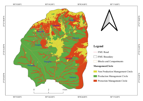 |
Figure 4: Map of Gogona FMU indicating the management circles
During the 1st MP period (2005-2015), the total Annual Allowable Cut (AAC) was set at 7900m3 inclusive of allotment for rural/local use. Likewise, during the 2nd MP period (2015-2025) the annual AAC was set at 6328m3 (5161m3 for commercial purpose, 1167m3 for rural use) and for the 3rd MP period (2025-2035), the annual AAC is set at 5768 (4790m3 for commercial purpose, 978m3 for rural/local use).
As per the latest statistics, the FMU almost entirely falls inside the Biological Corridor-8 with forest coverage of 61% of its total area. The forest is dominated by Fir (47%) and Hemlock (35%), with smaller areas of Blue Pine, Spruce, and Cool Broadleaved forests. The terrain is mostly moderate slopes (89% < 35%), with the remaining area designated for soil protection or conservation.
The primary overall goal of establishing the Forest Management Unit is to “Manage the forest for multiple uses, sustained yield for the production of timber, firewood and other forest produce and for conservation and protection of watershed, wildlife and environment”.
- Khotokha Forest Management Unit
The Office of the Khotokha FMU is located at Khotokha under Ruebisa gewog of Wangdue Phodrang Dzongkhag, located at 27° 26′ 25.26″ ° N latitude, 90° 0′ 13.428″ ° E longitude
Khotokha FMU falls under two gewogs, namely Bjena and Ruebisa, under Wangdue Phodrang Dzongkhag. Khotokha Forest Management Unit was established in 1984. The FMU lies between 90°15’5” and 90° 32’ 20” East longitude and 27°26’5” and 27° 32’ 20” North latitude. The elevation of the KFMU ranges from 2,300 meters at the valley bottom to 3,800 meters at the ridge top.
The Khotokha FMU initially covered 9,281.027 ha under the Third Management Plan (2019–2029). Following the allocation of 373.74 ha for the Gyalsung Project in 2020, the Fourth Management Plan was revised in 2021. The revision excluded the area allocated for Gyalsung and incorporated 126.586 ha of Ramsar site into the FMU’s protection area in accordance with the revised Forest and Nature Conservation Code of Best Management Practices of Bhutan (2021). Consequently, the current total area of the FMU stands at 9,033.874 ha, subject to further adjustments upon the full establishment of the Gyalsung Project.
Khotokha serves as a traditional grazing ground for the communities of Bjena and Ruebisa Gewogs. The residents practice seasonal migration, maintaining summer settlements within the upland areas of Khotokha FMU and winter homes in the lowlands outside the FMU boundary. Within the FMU, there are 19 hamlets comprising 111 households with a total population of approximately 671 people.
The forests of Khotokha FMU are broadly categorized into three major types: Mixed Conifer, Blue Pine, and Mixed Broadleaf forests. Mixed Conifer forests, comprising hemlock, fir, and spruce, are distributed throughout the FMU, while Blue Pine forests occur mainly in mid-elevation and drier inner valleys along the southeastern slopes. Mixed Broadleaf forests are concentrated in the southern part of the FMU along Paza Chhu. The humid conditions support a rich understory of rhododendrons, shrubs, and herbaceous species, including Primula species.
The Annual Allowable Cut (AAC) under the third Management Plan of Khotokha FMU is set at 9,400 m³, including 1,900 m³ allocated for rural use. Over the past ten years, total timber extraction amounted to 72,824.558 m³ for commercial use and 16,748.27 m³ for rural use (as of August 2019, in standing volume). Compared to the allocated AAC, both commercial and rural timber extraction remained below the prescribed limits, with deficits of 2,175.442 m³ and 2,251.73 m³, respectively, indicating sustainable harvesting within the allowable limits.
A total of 50.5 km of forest road has been constructed in FMU during the last three Plan periods. The road network has immensely benefited the local people residing within the FMU.
The overall goal of Khotokha FMU is to “manage the forest on a multiple-use, sustained yield basis for the production of timber, fuel wood, and other forest products and for watershed, wildlife, and environmental protection.”
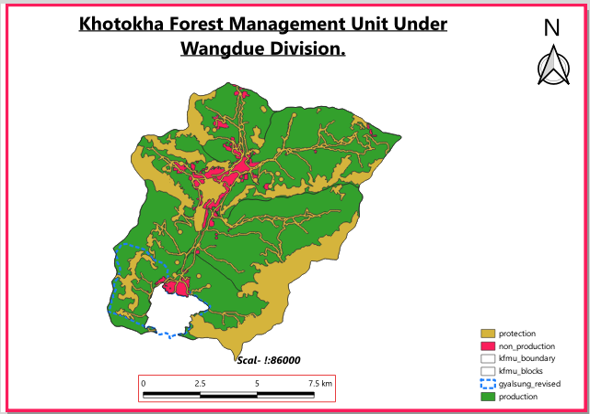 |
Figure 5: Map of Khotokha FMU indicating the management circles
- Royal Botanical Park, Lampelri
Royal Botanical Park, Lampelri (RBP) was designated as a conservation area in 2004 and formally inaugurated and opened to the public in 2008, coinciding with the coronation of His Majesty The Fifth King. It is recognized as Bhutan’s first recreational park, created with a dual mandate of conservation and nature-based recreation. Spanning 91.19 km² across the Sinchula–Dochula–Helela landscape, the park was established to safeguard the region’s rich biodiversity from degradation caused by unplanned human activities and increasing anthropogenic pressure. Its forests ranging from temperate broadleaf to mixed conifer stands harbor diverse flora and fauna, including extensive rhododendron habitats, moss-laden canopies, and intact understory ecosystems.
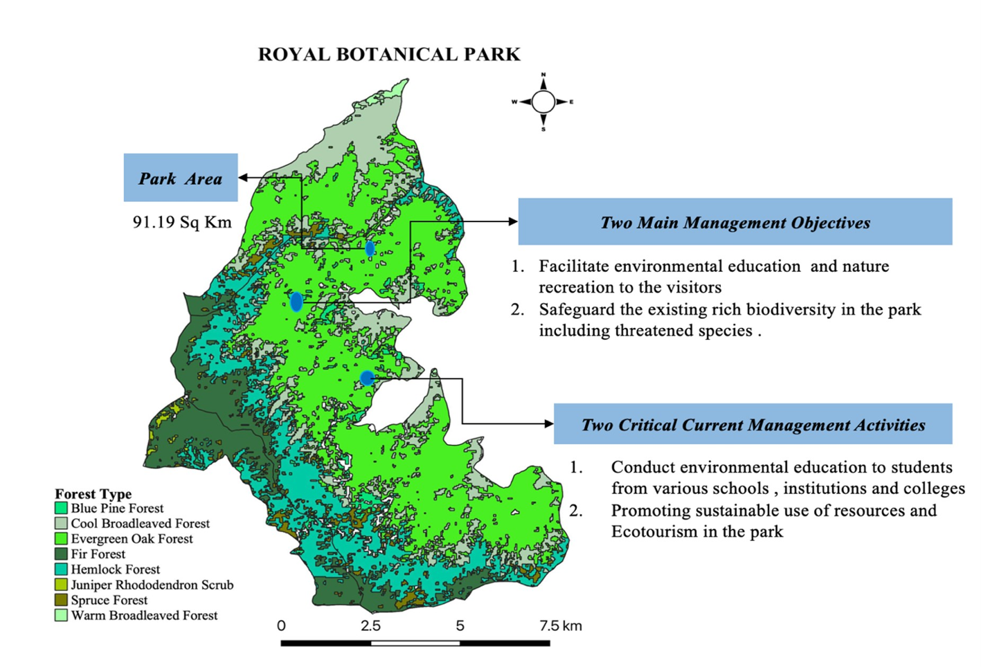 |
Figure 5: Map of Lampelri Botanical Park
Beyond its scenic and botanical value, Royal Botanical Park performs a vital ecological function as a biological corridor. It links Jigme Dorji Wangchuck National Park in the north with Jigme Singye Wangchuck National Park in the east, enabling the free movement of wildlife and supporting gene flow among plant and animal populations. This connectivity maintains habitat continuity across a broad landscape, reduces fragmentation, and strengthens ecosystem resilience to environmental change.
Hydrologically, the park is equally significant. It forms part of the watershed for the Wangchhu and Punatsangchhu river systems, with important catchments such as the Simtokha Rongchu and Toebisa Rongchu originating within its boundaries. The protection of these headwaters contributes directly to downstream water security and ecological stability.
Royal Botanical Park also holds exceptional promise as a center for ecotourism, environmental education, and nature recreational activities. It is a favored destination for birdwatchers, hikers, researchers, and nature enthusiasts. Through guided trails, interpretation, and conservation outreach, the park strives to cultivate environmental awareness among Bhutanese citizens and international visitors alike fostering a deeper appreciation and lasting stewardship for nature.
Forest Management Regimes under DFO, Wangdue
The forest management regimes within DFO, Wangdue include:
| Sl. No. | Forest Management Regimes | Primary Objective | Location within DFO, Wangdue’s jurisdiction |
| 01 | Forest Management Units (FMUs) | Sustainable commercial timber production through scientific forest management while maintaining ecological integrity. | Gogona and Khotokha FMU under Wangdue Phodrang Dzongkhag. |
| 02 | Local Forest Management Areas (LFMAs) | Ensure sustainable supply of forest products for local residents | Toebisa, Kabjisa and Barp gewogs under Punakha. Dangchu, Nahi, Daga, Gangtey, Phobji, Sephu, Bjena, Kazhi, and Gasetsho Wom gewogs under Wangdue Phodrang Dzongkhag |
| 03 | Biological Corridors (BCs) | Maintain landscape connectivity between protected areas, facilitate wildlife movement, and conserve biodiversity while allowing regulated community use | BC-02- Covers Nahi, Gasetsho Wom, Daga, Gasetsho Gom. Area: 28,273.096 ha. BC-08: Covers Athang, Gangtey, Bjena, Sephu Nyisho, Kazhi, Dangchu. Area: 43,813.637 Ha. |
| 04 | Community Forests (CFs) | Empower local communities to sustainably manage and utilize nearby forests for timber, fuelwood, non-wood forest products, and environmental conservation | 41 CFs under Punakha and 87 CFs under Wangdue Phodrang Dzongkhag. |
| 05 | Royal Botanical Park | To conserve Bhutan’s rich floral diversity while promoting environmental education, scientific research, nature-based recreation, and ecotourism | Lamperi under Toepisa gewog, Punakha, and Chang gewog of Thimphu Dzongkhag |
| 06 | Ramsar Sites | Two Ramsar sites, important wetland internationally recognized for conservation of habitats for Black Necked Cranes and other water birds | Gangtey, Phobjikha (961.554 ha) and Khotokha (126.585 ha) under Wangdue Phodrang Dzongkhag |
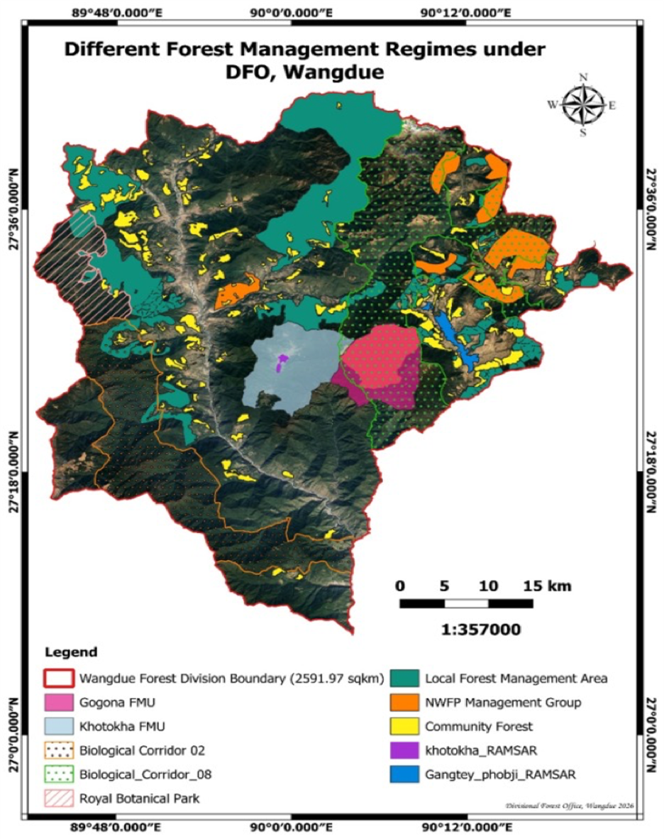 |
Figure 2: Map showing different forest management regimes under DFO, Wangdue.
The Divisional Forest Office also looks after the Biological Corridor Two (BC-2) which is the most significant corridor that connects Jigme Singye Wangchuck National Park in the southeast and Royal Botanical Park which further connects with Jigme Dorji National Park in the North. The majority of BC8 also falls under our jurisdiction and we are implementing most of the BC8 activities. However, DFO Bumthang is the sole responsible for managing the BC8 activities.
Forest Types of DFO-Wangdue
| Forest Types | Area (Ha) | Percent (%) |
| Blue Pine Forest | 7391.14 | 3.30% |
| Hemlock Forest | 29,008.39 | 12.93% |
| Chirpine Forest | 18,072.18 | 39% |
| Fir Forest | 42,021.15 | 19% |
| Spruce Forest | 2269.38 | 1% |
| Juniper Rhododendron Scrub | 6083.66 | 3% |
| Evergreen Oak Forest | 45,339.55 | 20% |
| Warm Broadleaved Forest | 24,963.94 | 11% |
| Subtropical Forest | 2,130.44 | 1% |
| Cool Broadleaved Forest | 46,692.01 | 21% |
| Total Forest Area | 22,3971.84 | 86% |
| Dry Alpine Scrub | 1,446.18 | |
| Non-Forest | 33,676.96 | |
| Total Non-Forest Area | 35,123.14 | 14% |
Summary of National Forestry Inventory in DFO, Wangdue.
| Particulars | Wangdue Phodrang | Punakha |
| NFI Plots | 251 NFI plots (196 accessible, 55 inaccessible): 78% | 70 NFI plots (54 accessible, 16 inaccessible): 77% |
| Estimated total trees | 393 per ha (101 m trees, highest) | 359 trees per ha |
| Estimated total saplings | 205 per ha | 172 per ha |
| Basal Area | 35.19 m2 (9.11 m m2, greatest) | 35.18 m2 |
| Growing stock | 298.61 m3/ha (7.73 m m3, greatest) | 292.55 m3 per ha |
| Forest Area (ha) | 258,969.43 (largest) | 88,699.01 |
| Forest Cover (%) | 65.14% | 80% |

